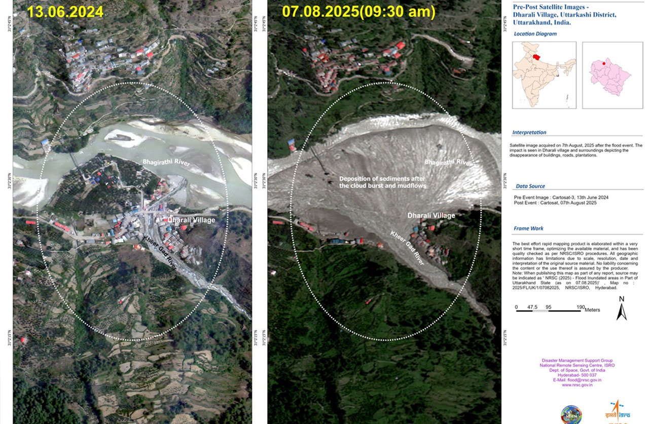
Satellite imagery from the Indian Space Research Organisation (ISRO) has starkly illustrated the extent of destruction caused by the recent flash flood in Dharali village, Uttarkashi district. According to India Today, the high-resolution visuals highlight massive changes in the landscape, with extensive damage to infrastructure and terrain.
Widespread Destruction Unveiled
Rapid post-event analysis using Cartosat-2S imagery, captured on August 7, 2025, reveals a dramatic transformation from pre-flood conditions documented on June 13, 2024. The most striking finding is a fan-shaped deposit of sediment and debris – spanning about 20 hectares at the confluence of the Kheer Gad stream and the Bhagirathi River.
The thick layer of silt and mud has buried large portions of Dharali, altered river channels, and engulfed homes and buildings. Many structures appear partially or completely washed away, with several areas rendered unrecognisable. These images provide critical insight into the scale and nature of the disaster.
Rescue Operations Intensify Amidst Chaos
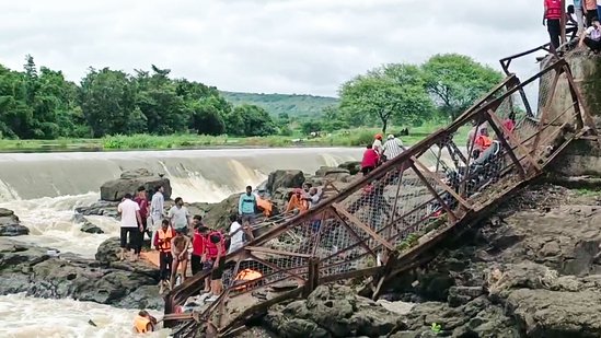
Authorities describe an increasingly grim situation on the ground. At least four people have been confirmed dead, while more than 50 remain missing, with fears that the toll may rise. Rescue and relief efforts have been intensified, with the Indian Army, National Disaster Response Force (NDRF), State Disaster Response Force (SDRF), and Indo-Tibetan Border Police (ITBP) deployed in large numbers.
Over 400 personnel are working around the clock, assisted by drones, sniffer dogs, and helicopters. However, rescue teams face significant challenges due to massive debris, some deposits reaching up to 50 feet high, spread across a 500-metre stretch. Several villages remain cut off after key access roads and bridges were destroyed.
Possible Causes Behind the Disaster
While initial speculation pointed to heavy rainfall, meteorological data has largely ruled out a traditional cloudburst. Experts now suggest that the devastation was likely triggered by a glacial lake outburst, glacier collapse, or a landslide surge. The sudden release of water and debris from unstable moraines or collapsing glacial formations appears consistent with satellite and ground observations.
Harrowing Accounts from Survivors
Eyewitnesses recall moments of sheer panic as the disaster struck. Survivors described hearing shouts to “run” as they saw a fast-moving wall of earth and water hurtling toward the village. Many spoke of escaping with nothing but the clothes on their backs, leaving behind homes and livelihoods in the chaos.
A Pattern of Himalayan Vulnerability
The Uttarkashi disaster adds to a growing list of extreme weather and geological events in the fragile Himalayan region. Experts point to rising temperatures, increased precipitation, deforestation, and unregulated development as key factors heightening vulnerability. Over the past decade, satellite and climate data have recorded a significant increase in extreme events, posing serious risks to both life and infrastructure in these high-altitude settlements.
ISRO’s satellite imagery not only documents the scale of the Uttarkashi flash flood but also plays a vital role in directing relief operations, assessing damage, and guiding long-term rehabilitation strategies.
Photo Source: ISRO (X)
For more stories click here
Follow us for latest updates: